-
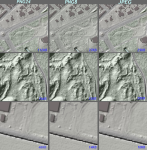
TL;DR: see this GitHub issue for summary (Dutch but the pictures there and Figure 1 tell the story). Somewhere around 1995, building my first website, it was already quite a feat to embed images. Non-aware of image-formats I played with (animated!) GIF and JPEG. Naively image-editing I noticed that my JPEGs became …
Read More -
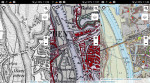
As far as Open geo-data is concerned, the Netherlands goes through prosperous times: country-wide datasets for detailed topography (BRT , BGT ), buildings and addresses (BAG ), 0.5m elevation data (AHN2 ) and many more are available for download. Even 3D-versions for several of these datasets are upcoming. These and …
Read More