-
One of my new year’s resolutions for 2018 was to “blog more”. Not being very active on the well-known social media: a bit tired of Twitter, never really into Facebook, bit of LinkedIn. OSGeo mailing lists , GitHub and Gitter is where you can find me most (thanks Jody, for reminding!). And I read many blogs, especially …
Read More -
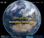
During June 21-24, 2016 I attended the very first GeoPython Conference in Basel Switzerland . This event was organized by the Institute of Geomatics Engineering of the FHNW – University of Applied Sciences and Arts Northwestern Switzerland and PyBasel , the local Python User Group Northwestern Switzerland. In …
Read More -

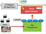
My blog has been quiet for some time. As many of us I’ve been busy doing projects, all involving Open Source Geo (OSGeo) software. Partly development, writing software, I love it, but also more and more in “what comes next”: deploying and maintaining “the application” with all of its dependencies. For this I have been …
Read More -
TL;DR: see this GitHub issue for summary (Dutch but the pictures there and Figure 1 tell the story). Somewhere around 1995, building my first website, it was already quite a feat to embed images. Non-aware of image-formats I played with (animated!) GIF and JPEG. Naively image-editing I noticed that my JPEGs became …
Read More -
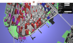
This is my list of FOSS products for 3D Geospatial with a focus on web technology/WebGL and Open Standards. These are notes I keep within Evernote as part of the 3D Geospatial Notebook whose public link is: https://www.evernote.com/pub/justb4ever/3d-geospatial. This is also the first experiment to auto sync Evernote to …
Read More -
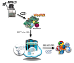
This is a follow-up to “Into the Weather – Part 1 – Exploring weewx” . Sorry, still almost no geospatial content for now. To recap: I am trying to setup an infrastructure where measurements from a Davis Vantage Pro2 Weather Station are collected and exposed to web services, most notably OGC Services like WMS-Time and …
Read More