Clarity
About
Writings icon
Blog Presentations Mastodon Publications
Projects icon
Overview Heron Mapping Client GeoHealthCheck – OGC GeoSpatial Web Service Monitoring Smart Emission – Open Sensor Web Platform Stetl – Streaming ETL NLExtract – Unlock Dutch Geodata INSPIRE FOSS – Free and Open Source for INSPIRE 7Scenes – create mobile games and tours MapGlow – heatmaps via WMS GeoSkating – map your inline skating tracks GeoRambling – Just’s Multimedial GPS Hikes Pushlets – PubSub via HTTP (stale) CowCatcher – Free Java Training Materials
Products icon
geotoko.nl - Ready Geodata map5.nl - Map Tiles geoqos.com - Hosted GeoHealthCheck
Contact
  • Adiós 2021

    Jan 4, 2022 · 13 min read · FOSS FOSS4G GeoFabriek GeoHealthCheck geoqos GeoSpatial geotoko.nl GIS GroteGeoShow Map5.nl NLExtract OSgeo OSGeo.nl python QGIS RTMP Streaming StreamYard  ·
    Share on:
    Adiós 2021

    Overview of my professional life in 2021. Highlights of living and working in the Open Source Geospatial and OSGeo(.nl |.org )-world in 2021. Organized by "Theme". Like 2020, 2021 was again a "special year" in pandemic terms. How to cope? Like Paul Ramsey writes: I feel like sharing some of my …

    Read More
  • That Was 2020

    Jan 20, 2021 · 10 min read · FOSS FOSS4G GeoFabriek GeoHealthCheck geoqos GeoSpatial geotoko.nl GIS GroteGeoShow Map5.nl NLExtract OSgeo OSGeo.nl python QGIS RTMP Streaming StreamYard  ·
    Share on:
    That Was 2020

    Overview of my professional life in 2020. Highlights of living and working in the Open Source Geospatial and OSGeo(.nl |.org )-world in 2020. Organized by “Theme”. Yes, 2020 was a “special year” in pandemic and political terms. So much has been written and opinions expressed, that I don’t see a need to add to more …

    Read More
  • Cheers to 2018

    Jan 11, 2019 · 7 min read · FOSS4G GeoSpatial GIS NLExtract OSgeo PostGIS SensorThings SWE  ·
    Share on:
    Cheers to 2018

    Never too late to look back. Inspired by the concise bullet-point-style of Tom Kralidis’ Cheers to 2018 , my personal highlights of living and working in the Open Source Geospatial and OSGeo(.nl|org)-world in 2018. I’ll post 2019 reso’s later. Not just personal projects, but also events from the OSGeo.nl Local Chapter …

    Read More
  • Emit #1 – Into Spatiotemporal

    Jan 20, 2018 · 6 min read · air quality FOSS FOSS4G gdal geoserver GeoSpatial GIS NLExtract PostGIS sensors SensorThings SOS stetl  ·
    Share on:
    Emit #1 – Into Spatiotemporal

    One of my new year’s resolutions for 2018 was to “blog more”. Not being very active on the well-known social media: a bit tired of Twitter, never really into Facebook, bit of LinkedIn. OSGeo mailing lists , GitHub and Gitter is where you can find me most (thanks Jody, for reminding!). And I read many blogs, especially …

    Read More
  • JPEG is Dead, Long Live JPEG!

    May 21, 2015 · 5 min read · gdal GeoSpatial GIS JPEG Map5.nl MapProxy MapServer NLExtract OpenTopo OSgeo  ·
    Share on:
    JPEG is Dead, Long Live JPEG!

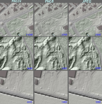
    TL;DR: see this GitHub issue for summary (Dutch but the pictures there and Figure 1 tell the story). Somewhere around 1995, building my first website, it was already quite a feat to embed images. Non-aware of image-formats I played with (animated!) GIF and JPEG. Naively image-editing I noticed that my JPEGs became …

    Read More
  • Tales from Topographic Lowlands

    May 8, 2015 · 4 min read · GIS Map5.nl NLExtract openstreetmap OpenTopo OSgeo  ·
    Share on:
    Tales from Topographic Lowlands

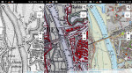
    As far as Open geo-data is concerned, the Netherlands goes through prosperous times: country-wide datasets for detailed topography (BRT , BGT ), buildings and addresses (BAG ), 0.5m elevation data (AHN2 ) and many more are available for download. Even 3D-versions for several of these datasets are upcoming. These and …

    Read More

Just Objects B.V.

is the trading name for the professional activities of Just van den Broecke.
Read More

Recent Posts

  • Adiós 2021
  • Terraform - First Steps on Hetzner Cloud
  • That Was 2020

Categories

PROJECTS 36 OSGEO 34 SOFTWARE 32 GENERAL 23 MOBILE 13
All Categories
GENERAL23 MEDIATECH5 MOBILE13 OSGEO34 PROJECTS36 SMARTEMISSION8 SOFTWARE32
[A~Z][0~9]

Tags

GEOSPATIAL 18 OSGEO 18 GIS 14 FOSS4G 11 FOSS 9
All Tags
3D2 3DPS2 AIR-QUALITY1 AIRQUALITY1 AIRSENSEUR1 ANSIBLE1 BASEL1 BIM1 CESIUM3 COLLADA1 COLORADO1 D3JS1 DENVER1 DEVOPS1 DOCKER2 EPGS289921 EVOLUTION1 FOSS9 FOSS4G11 GDAL7 GEODJANGO1 GEOFABRIEK2 GEOHEALTHCHECK2 GEONODE1 GEONOVUM2 GEOP1 GEOQOS2 GEOSERVER3 GEOSPATIAL18 GEOTOKO.NL2 GIS14 GITOPS1 GPS1 GRASS1 GROTEGEOSHOW2 IOT3 JPEG1 LORA1 LORAWAN1 MAP51 MAP5.NL5 MAPNIK1 MAPPROXY1 MAPSERVER1 NATURAL-NAVIGATION1 NIJMEGEN1 NLEXTRACT6 NLTOPO1 OGC7 OPENLAYERS1 OPENSTREETMAP1 OPENTOPO2 OSGEO18 OSGEO.NL2 OSLANDIA1 OSM2 PACKAGING1 POSTGIS6 PROJ1 PYTHON6 QGIS3 RASPBERRY-PI2 RTMP2 SENSORS1 SENSORTHINGS8 SENSORWEB1 SOS6 SOTM1 STANDARDS1 STETL2 STREAMING2 STREAMYARD2 SWE6 TERRAFORM1 THETHINGSNETWORK1 THREEJS1 TILECACHE1 TOP10NL1 WEATHER3 WEATHER-UNDERGROUND3 WEEWX3 WFS1 WMS3 X3D1
[A~Z][0~9]
Clarity

Copyright  CLARITY. All Rights Reserved