Clarity
About
Writings icon
Blog Presentations Mastodon Publications
Projects icon
Overview Heron Mapping Client GeoHealthCheck – OGC GeoSpatial Web Service Monitoring Smart Emission – Open Sensor Web Platform Stetl – Streaming ETL NLExtract – Unlock Dutch Geodata INSPIRE FOSS – Free and Open Source for INSPIRE 7Scenes – create mobile games and tours MapGlow – heatmaps via WMS GeoSkating – map your inline skating tracks GeoRambling – Just’s Multimedial GPS Hikes Pushlets – PubSub via HTTP (stale) CowCatcher – Free Java Training Materials
Products icon
geotoko.nl - Ready Geodata map5.nl - Map Tiles geoqos.com - Hosted GeoHealthCheck
Contact
  • Second Time Around – WFS v3 and pygeoapi

    May 31, 2019 · 5 min read · ogc OSgeo python wfs  ·
    Share on:
    Second Time Around – WFS v3 and pygeoapi

    TLDR; tired of the OGC WFS/GML/INSPIRE complexity mess new spirit from WFS v3 standard and OGC REST API movement title of this blog refers (YouTube): Shalamar, The Second Time Around . pygeoapi implements OGC REST APIs in Python I joined pygeoapi pygeoapi can unlock/proxy existing WFS v1,v2 and any OGR Source! About …

    Read More
  • Emit #6 – AirSensEUR Calibration

    Feb 19, 2019 · 7 min read · airquality GeoSpatial iot nijmegen ogc OSgeo SensorThings sensorweb SOS SWE wms  ·
    Share on:
    Emit #6 – AirSensEUR Calibration

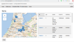
    This is Emit #6, in a series of blog-posts around the Smart Emission Platform , an Open Source software component framework that facilitates the acquisition, processing and (OGC web-API) unlocking of spatiotemporal sensor-data, mainly for Air Quality and other environmental sensor-data like noise. In Emit #5 – …

    Read More
  • Deploying Open Source Geospatial Software – Part 1: Challenges

    Jun 10, 2016 · 5 min read · docker FOSS4G gdal GeoSpatial GIS ogc OSgeo packaging  ·
    Share on:
    Deploying Open Source Geospatial Software – Part 1: Challenges

    My blog has been quiet for some time. As many of us I’ve been busy doing projects, all involving Open Source Geo (OSGeo) software. Partly development, writing software, I love it, but also more and more in “what comes next”: deploying and maintaining “the application” with all of its dependencies. For this I have been …

    Read More
  • Unlocking Sensor Data – I’ll send an SOS to the world

    Oct 1, 2015 · 3 min read · FOSS4G geonovum GeoSpatial iot ogc OSgeo SensorThings SOS standards SWE  ·
    Share on:
    Unlocking Sensor Data – I’ll send an SOS to the world

    Revealing: the title refers, for the younger readers, to a great 1979-hit by The Police as expanded below. To be played at the loudest possible volume. If you don’t see anything here below try the YouTube link directly: One of the main aspects that glues the OSGeo-world together are OGC-standards: WMS, WFS, WMTS, WCS …

    Read More
  • 3D Geospatial – Open Standards – v0

    Jan 29, 2015 · 12 min read · 3D 3DPS BIM Cesium COLLADA FOSS4G GeoSpatial GIS ogc OSgeo X3D  ·
    Share on:
    3D Geospatial – Open Standards – v0

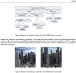
    This is my evolving overview of 3D Geospatial Open Standards with a focus on web technology: services, HTML5, WebGL. These are notes I keep within Evernote as part of the 3D Geospatial Notebook whose public link is: https://www.evernote.com/pub/justb4ever/3d-geospatial. For sure, resources are missing, let me know. …

    Read More
  • 3D Geospatial – Free and Open Source Software v0

    Jan 28, 2015 · 5 min read · 3D 3DPS Cesium D3JS FOSS FOSS4G gdal GeoSpatial ogc OpenLayers OSgeo OSLandia PostGIS ThreeJS  ·
    Share on:
    3D Geospatial – Free and Open Source Software v0

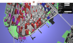
    This is my list of FOSS products for 3D Geospatial with a focus on web technology/WebGL and Open Standards. These are notes I keep within Evernote as part of the 3D Geospatial Notebook whose public link is: https://www.evernote.com/pub/justb4ever/3d-geospatial. This is also the first experiment to auto sync Evernote to …

    Read More
  • Into the Weather – Part 3 – Publishing Data to the Cloud – 1

    Dec 15, 2014 · 4 min read · geoserver ogc OSgeo PostGIS raspberry pi SensorThings SOS SWE weather weather underground weewx wms  ·
    Share on:
    Into the Weather – Part 3 – Publishing Data to the Cloud – 1

    In my last post, Into the Weather – Part 2 , I outlined a global architecture of a Davis Vantage Pro2 weather station connected to a Raspberry Pi (RPi) running weewx weather software to capture raw weather data. Here I will try to depict how to bring this weather data “from the fluffy clouds into the digital cloud”. …

    Read More

Just Objects B.V.

is the trading name for the professional activities of Just van den Broecke.
Read More

Recent Posts

  • Adiós 2021
  • Terraform - First Steps on Hetzner Cloud
  • That Was 2020

Categories

PROJECTS 36 OSGEO 34 SOFTWARE 32 GENERAL 23 MOBILE 13
All Categories
GENERAL23 MEDIATECH5 MOBILE13 OSGEO34 PROJECTS36 SMARTEMISSION8 SOFTWARE32
[A~Z][0~9]

Tags

GEOSPATIAL 18 OSGEO 18 GIS 14 FOSS4G 11 FOSS 9
All Tags
3D2 3DPS2 AIR-QUALITY1 AIRQUALITY1 AIRSENSEUR1 ANSIBLE1 BASEL1 BIM1 CESIUM3 COLLADA1 COLORADO1 D3JS1 DENVER1 DEVOPS1 DOCKER2 EPGS289921 EVOLUTION1 FOSS9 FOSS4G11 GDAL7 GEODJANGO1 GEOFABRIEK2 GEOHEALTHCHECK2 GEONODE1 GEONOVUM2 GEOP1 GEOQOS2 GEOSERVER3 GEOSPATIAL18 GEOTOKO.NL2 GIS14 GITOPS1 GPS1 GRASS1 GROTEGEOSHOW2 IOT3 JPEG1 LORA1 LORAWAN1 MAP51 MAP5.NL5 MAPNIK1 MAPPROXY1 MAPSERVER1 NATURAL-NAVIGATION1 NIJMEGEN1 NLEXTRACT6 NLTOPO1 OGC7 OPENLAYERS1 OPENSTREETMAP1 OPENTOPO2 OSGEO18 OSGEO.NL2 OSLANDIA1 OSM2 PACKAGING1 POSTGIS6 PROJ1 PYTHON6 QGIS3 RASPBERRY-PI2 RTMP2 SENSORS1 SENSORTHINGS8 SENSORWEB1 SOS6 SOTM1 STANDARDS1 STETL2 STREAMING2 STREAMYARD2 SWE6 TERRAFORM1 THETHINGSNETWORK1 THREEJS1 TILECACHE1 TOP10NL1 WEATHER3 WEATHER-UNDERGROUND3 WEEWX3 WFS1 WMS3 X3D1
[A~Z][0~9]
Clarity

Copyright  CLARITY. All Rights Reserved