Clarity
About
Writings icon
Blog Presentations Mastodon Publications
Projects icon
Overview Heron Mapping Client GeoHealthCheck – OGC GeoSpatial Web Service Monitoring Smart Emission – Open Sensor Web Platform Stetl – Streaming ETL NLExtract – Unlock Dutch Geodata INSPIRE FOSS – Free and Open Source for INSPIRE 7Scenes – create mobile games and tours MapGlow – heatmaps via WMS GeoSkating – map your inline skating tracks GeoRambling – Just’s Multimedial GPS Hikes Pushlets – PubSub via HTTP (stale) CowCatcher – Free Java Training Materials
Products icon
geotoko.nl - Ready Geodata map5.nl - Map Tiles geoqos.com - Hosted GeoHealthCheck
Contact
  • Into the Weather – Part 3 – Publishing Data to the Cloud – 1

    Dec 15, 2014 · 4 min read · geoserver ogc OSgeo PostGIS raspberry pi SensorThings SOS SWE weather weather underground weewx wms  ·
    Share on:
    Into the Weather – Part 3 – Publishing Data to the Cloud – 1

    In my last post, Into the Weather – Part 2 , I outlined a global architecture of a Davis Vantage Pro2 weather station connected to a Raspberry Pi (RPi) running weewx weather software to capture raw weather data. Here I will try to depict how to bring this weather data “from the fluffy clouds into the digital cloud”. …

    Read More
  • Open Source and The Theory on Brontosauruses by Anne Elk (Miss)

    Nov 20, 2014 · 3 min read  ·
    Share on:
    Open Source and The Theory on Brontosauruses by Anne Elk (Miss)

    Preparing for a talk on our OSGeo.nl Day at the Dutch GeoBuzz Conference, I am trying to put in some slides on Free and Open Source Software (FOSS) for geospatial: why “FOSS is good” and why I live by it. The usual arguments on licensing, (not) price, feature comparison, collaboration contrasted with proprietary source …

    Read More
  • Into the Weather – Part 2 – Fun with Raspberry Pi

    Nov 6, 2014 · 4 min read · gdal geoserver GeoSpatial GIS OSgeo PostGIS raspberry pi SensorThings SOS SWE weather weather underground weewx wms  ·
    Share on:
    Into the Weather – Part 2 – Fun with Raspberry Pi

    This is a follow-up to “Into the Weather – Part 1 – Exploring weewx” . Sorry, still almost no geospatial content for now. To recap: I am trying to setup an infrastructure where measurements from a Davis Vantage Pro2 Weather Station are collected and exposed to web services, most notably OGC Services like WMS-Time and …

    Read More
  • Into the Weather – Part 1 – Exploring weewx

    Oct 17, 2014 · 4 min read · weather weather underground weewx  ·
    Share on:
    Into the Weather – Part 1 – Exploring weewx

    Tagging this post as “Part 1” is ambitious. Beware: there is hardly any “geo” for now. In the coming time I hope to share some technical experiences with weather stations, weather software and ultimately exposing weather data via some open geospatial standards like OGC WMS(-Time) as in example image right , WFS and in …

    Read More
  • Unlocking the amazing OpenTopo.nl Maps

    Oct 13, 2014 · 3 min read  ·
    Share on:
    Unlocking the amazing OpenTopo.nl Maps

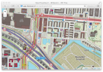
    The essence of this post is to illustrate via some web-apps the great topographic mapping done by Jan-Willem van Aalst using Dutch free geo-data. The summary/TL;DR is: great maps produced from Dutch Open Data by Jan-Willem van Aalst unlocked by me via web tiling services and simple web apps like this one . The longer …

    Read More
  • New website – but what is Open Geospatial?

    Jul 3, 2014 · 2 min read  ·
    Share on:
    New website – but what is Open Geospatial?

    This is a “sign-of-life-post” as my last blog was in 2013. After too many years, I created a new website for justobjects.nl which also integrates my barren blog. These days, making a website is a breeze thanks to WordPress (WP) and responsive design themes. WP provides an ideal dynamic platform (just update regularly …

    Read More
  • Moving PostGIS tables from the public schema to a new schema

    Feb 1, 2013 · 2 min read · PostGIS  ·
    Share on:
    Moving PostGIS tables from the public schema to a new schema

    Update 30 nov 2013: code is now as a GIST on GitHub , also with function to move single table. Update 19 feb 2014: not yet tested with PostGIS v2.0 and up, so beware (or let me know if that works)! Update 4 june 2015: _tested with PostgreSQL 9.3.4 and PostGIS v2.1: all ok!! _ Using PostgreSQL Schema’s when using …

    Read More
  • OSGeo Open Source Seminar at Geospatial World Forum

    Apr 17, 2012 · 2 min read · FOSS GIS OSgeo  ·
    Share on:

    The OSGeo Foundation has been invited to provide a 4-hour Open Source Seminar at the Geospatial World Forum . This event will take place on April 25, 2012 in the RAI Amsterdam, The Netherlands . As Trailblazer (Dutch “Kwartiermaker”) for the newly formed OSGeo.nl Dutch Language Chapter I was in charge of finding …

    Read More
  • SOTM and FOSS4G Conferences 2011 Denver

    Sep 20, 2011 · 2 min read · Colorado Denver FOSS FOSS4G GeoSpatial GIS OSgeo osm SOTM  ·
    Share on:

    What a great time it was in Denver, Colorado, USA ! Attended both the OpenStreetMap State Of The Map (OSM SOTM) and the OSGeo Free and Open Source for Geo (FOSS4G) conferences between september 9 and 16, 2011. Went hiking in between in the Rocky Mountains (State Park and Indian Peaks Wilderness ) where I saw a live …

    Read More
  • OSGeo Code Sprint Bolsena 2010

    Jul 23, 2010 · 1 min read  ·
    Share on:

    Like in 2009 , I attended the OSGeo Code Sprint (and Hacking Event) in Bolsena, Italy during June 6-12, 2010. For one week developers from various Free and Open Source for Geospatial (often abbreviated as FOSS4G) projects get together in a monastery near Bolsena for code sprints, cross-project collaborations, …

    Read More
    • ««
    • «
    • 1
    • 2
    • 3
    • 4
    •  … 
    • 6
    • »
    • »»

Just Objects B.V.

is the trading name for the professional activities of Just van den Broecke.
Read More

Recent Posts

  • Adiós 2021
  • Terraform - First Steps on Hetzner Cloud
  • That Was 2020

Categories

PROJECTS 36 OSGEO 34 SOFTWARE 32 GENERAL 23 MOBILE 13
All Categories
GENERAL23 MEDIATECH5 MOBILE13 OSGEO34 PROJECTS36 SMARTEMISSION8 SOFTWARE32
[A~Z][0~9]

Tags

GEOSPATIAL 18 OSGEO 18 GIS 14 FOSS4G 11 FOSS 9
All Tags
3D2 3DPS2 AIR-QUALITY1 AIRQUALITY1 AIRSENSEUR1 ANSIBLE1 BASEL1 BIM1 CESIUM3 COLLADA1 COLORADO1 D3JS1 DENVER1 DEVOPS1 DOCKER2 EPGS289921 EVOLUTION1 FOSS9 FOSS4G11 GDAL7 GEODJANGO1 GEOFABRIEK2 GEOHEALTHCHECK2 GEONODE1 GEONOVUM2 GEOP1 GEOQOS2 GEOSERVER3 GEOSPATIAL18 GEOTOKO.NL2 GIS14 GITOPS1 GPS1 GRASS1 GROTEGEOSHOW2 IOT3 JPEG1 LORA1 LORAWAN1 MAP51 MAP5.NL5 MAPNIK1 MAPPROXY1 MAPSERVER1 NATURAL-NAVIGATION1 NIJMEGEN1 NLEXTRACT6 NLTOPO1 OGC7 OPENLAYERS1 OPENSTREETMAP1 OPENTOPO2 OSGEO18 OSGEO.NL2 OSLANDIA1 OSM2 PACKAGING1 POSTGIS6 PROJ1 PYTHON6 QGIS3 RASPBERRY-PI2 RTMP2 SENSORS1 SENSORTHINGS8 SENSORWEB1 SOS6 SOTM1 STANDARDS1 STETL2 STREAMING2 STREAMYARD2 SWE6 TERRAFORM1 THETHINGSNETWORK1 THREEJS1 TILECACHE1 TOP10NL1 WEATHER3 WEATHER-UNDERGROUND3 WEEWX3 WFS1 WMS3 X3D1
[A~Z][0~9]
Clarity

Copyright  CLARITY. All Rights Reserved